Geography Of The Oromocto River Watershed
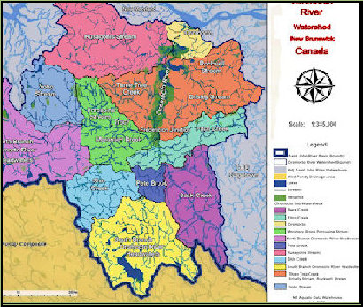
The Oromocto River Watershed is nearly 1/2 the size of Prince Edward Island and occupies space in four counties, Sunbury, York, Charlotte and Queens. It is located in Southwestern New Brunswick, Canada.
The drainage area is approximately 2500 square kilometers. This includes the Town of Oromocto and the communities of Lincoln, Rusagonis, Waasis, Waterville, Haneytown, Base Gagetown, Geary, French Lake, Hanwell, Nasonworth, Charters Settlement, New Maryland, Beaverdam, Tracy, Yoho Lake, Little Lake Road, Cork Station, Harts, Harvey, Tweedside, Blissville, Hoyt, Patterson, Wirral, Enniskillen, Mill Settlement, Juvenile Settlement, Sand Brook, Back Clarendon, North Oromocto Lake and South Oromocto Lake.
The top of the watershed consists of North Oromocto Lake and South Oromocto Lake. These large lakes are crystal clear and average about 7 meters in depth. North Oromocto Lake (13km x 4.5km) is near Harvey N.B. The North Branch (45km) flows east northeast through the villages of Tracy and Fredericton Junction. South Oromocto Lake is 7 km long and 2 km wide. The South Branch is 39 km long and flows north-northeast through the communities of Hoyt and Central Blissville. The two branches join near Central Blissville and flow 42 km north-northeast to its mouth at the Saint John River by the Town of Oromocto.
Both branches (North and South) are fast running with many tributaries. The main Oromocto becomes tidal in low water for approximately 40 km to its mouth. This tidal area forms a calm, flat basin containing many streams, lakes and ponds.
The early spring freshet adds 6 meters to the depth over summer and creates a flood plane reservoir of approximately 45 km by 3 km.


